The
Sindh plain comprises mainly the province
of Sindh and stretches between the Punjab
plain and the arabian Sea. River Indus
flows here as a single river and the plain
comprises a vast fertile tract stretching
westward from the narrow strip of flood
plain on the right bank of River Indus,
and a vast expanse of desert stretching
eastward from the left bank. The desert
area is dry and desolate like Cholistan in
the Punjab plain. But, the plain area
right of River Indus is green with a vast
stretches of vegetation lined everywhere
with avenues of trees.
It
is the heart of the Indus Valley
Civilization dating back to 3rd
millennium B.C. Thousands of tourists from
all over the world are attracted every
year to visit the ruins of Moenjodaro near
Larkana. An elaborate canal system taken
from Sukkur Barrage at Sukkur, Upper Sindh
Barrage north of Sukkur at Guddu, and
Lower Sindh Barrage (Ghulam Muhammad
Barrage) at Hyderabad, irrigate together
in this area over 10,000,0000 acres and
account for about 40 per cent of
Pakistan's irrigated land. The fertile
area yields abundant crops of rice, wheat
and cotton and contains the bulk of the
population and most of the major
commercial and industrial centres of Sindh
such as Hyderabad(795,000), Sukkur
(193,000), Larkana (123,000), Nawabshah
(102,000), Shikarpur (88,000) and Dadu
(39,000).
However, its southern part is one of the
worst areas of Pakistan for waterlogging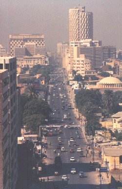 and salinity. There are many lakes in
Sindh,which attract thousands of migratory
birds during the winter season from
Central Asia. Manchhar lake with its
highly pulsating expanse of about 200
sq.miles of area is the largest lake. With
its foliage of towering grasses, its
meadows of floating lotus, its inhabitants
in their floating habitations, the lake
presents an attractive look. Further
south, stretches the Indus Delta, which is
a savage waste. An important feature is
the Kinjhar Lake near Thatta, which acts
as a great reservoir for feeding canals in
the adjacent areas. During winter, it is
an ideal spot for fishing and duck
shooting. South of the Kinjhar Lake, the
surface is broken and littered with
abandoned channels of distributaries,
sandy beaches, ridges and mangrove swamps,
all merging into the dead creeks, grate
and salt water of the coast of Rann of
Kutch. At the extreme north-western end of
the delta stands Karachi, the largest city
and the industrial and commercial hub of
Pakistan. It is also the port for Pakistan
and terminal of Pakistan's railway system
and the site of the country's principal
international airport. Climate and Seasons
As Pakistan is located on a great landmass
north of Tropic of Cancer, between
latitudes 24 and 37 N, it has a
continental type of climate, characterized
by extreme variations of temperature.
and salinity. There are many lakes in
Sindh,which attract thousands of migratory
birds during the winter season from
Central Asia. Manchhar lake with its
highly pulsating expanse of about 200
sq.miles of area is the largest lake. With
its foliage of towering grasses, its
meadows of floating lotus, its inhabitants
in their floating habitations, the lake
presents an attractive look. Further
south, stretches the Indus Delta, which is
a savage waste. An important feature is
the Kinjhar Lake near Thatta, which acts
as a great reservoir for feeding canals in
the adjacent areas. During winter, it is
an ideal spot for fishing and duck
shooting. South of the Kinjhar Lake, the
surface is broken and littered with
abandoned channels of distributaries,
sandy beaches, ridges and mangrove swamps,
all merging into the dead creeks, grate
and salt water of the coast of Rann of
Kutch. At the extreme north-western end of
the delta stands Karachi, the largest city
and the industrial and commercial hub of
Pakistan. It is also the port for Pakistan
and terminal of Pakistan's railway system
and the site of the country's principal
international airport. Climate and Seasons
As Pakistan is located on a great landmass
north of Tropic of Cancer, between
latitudes 24 and 37 N, it has a
continental type of climate, characterized
by extreme variations of temperature.
The
areas closer to the snow-covered northern
mountains are cold. Temperatures on the
Balochistan Plateau are comparatively
high. Along the coastal strop, the climate
is modified by sea breezes. In the rest of
the country, temperature rises steeply in
the summer and hot winds, called "loo",
blow across the plains during the day,
dust storms and thunder storms
occasionally lower the temperature. The
diurnal variation in temperature may be as
much as 11 to 17 oC. Winters are cold with
minimum temperature of about 4 oC in
January. Rainfall Pakistan experiences a
general deficiency of rainfall.